Region
Eastern Washington
Location: Columbia National Wildlife Refuge, Grant County Land Agency: U.S. Department of the Interior Contact: Columbia National Wildlife Refuge Roundtrip: 3.0 miles Elevation Gain: 300 feet Note: Dogs permitted on leash. Be snake and tick aware Good to know: dog-friendly, kid-friendly, spring wildflowers, exceptional birdwatching, snow-free hike Access: From Spokane, take I-90 west to Exit 179…
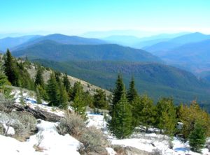
Quick Facts: Location: Kettle River Range, Sherman Pass Land Agency: Colville National Forest Roundtrip: 8.0 miles Elevation Gain: 1,360 feet Access: From Republic travel east 17 miles on SR 20 to trailhead at Sherman Pass. From Kettle Falls, follow SR 20 for 26 west miles to Sherman Pass. Contact: Colville National Forest, Republic Ranger District Good…

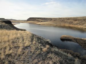
Wilderness and stark beauty along the Columbia River Quick Facts: Location: Hanford Reach National Monument Round Trip: 7.0 miles Elevation Gain: 500 feet Contact: Hanford Reach National Monument, Mid-Columbia River National Wildlife Recreation Complex; Detailed Information: Day Hiking Eastern Washington (Mountaineers Books) Notes: watch for rattlesnakes; pack lots of water Access: From Ellensburg, follow I-90…
Mega-fauna hot spot in the Kettle River Range Quick Facts: Location: Kettle River Range Land Agency: National Forest Service Distance: 7.4 miles Elevation Gain: 1975 feet Contact: Colville National Forest Three Rivers Ranger District Recommended Guidebook: Day Hiking Eastern Washington (Mountaineers Books) Access: From Kettle Falls, travel west on SR 20 for 14 miles turning…

Hike through an old town site along a tamed river Quick Facts: Location: Lake Roosevelt, Stevens County, WA Land Agency: National Park Service Roundtrip: 2.6 miles Elevation Gain: minimal Contact: Lake Roosevelt National Recreation Area Detailed Information: Day Hiking Eastern Washington (Mountaineers Books) Notes: Dogs permitted on leash Access: From Kettle Falls head west on SR 20-US 395…
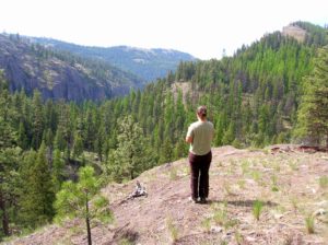
Quick Facts: Location: Abercrombie-Hooknose Roadless Area, Selkirk Mountains Land Agency: Colville National Forest Roundtrip: 7.4 miles Elevation gain: 2,300 feet Contact: Colville National Forest, Three Rivers Ranger District (Colville) (509) 684-3711 Notes: Access road requires high clearance vehicle Access: From Colville, Washington travel north on Aladdin Road (CR 9435) for 25 miles. Turn right on…
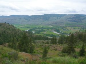
Location: Okanogan Valley near Oroville Land Agency: Okanogan-Wenatchee National Forest Roundtrip: 5.0 miles High Point: 1,950 feet Elevation gain: 1,250 feet Difficulty: moderate Contact: Pacific Northwest Trail Association Note: Dogs should be under strict control as to not disturb the bighorn sheep. Access: From Tonasket, follow US 97 north for 14.5 miles to trailhead turnoff…
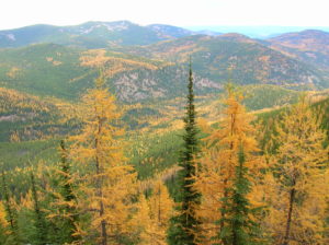
Location: Colville National Forest, near Republic Land Agency: US Forest Service Roundtrip: 8.0 miles High Point: 6,550 feet Elevation gain: 2,250 feet Difficulty: moderate Recommended Guidebook: Day Hiking Eastern Washington Contact: Colville National Forest Access: From Republic, head east on SR 20 for 25 miles turning left onto FR 2030 (Albion Hill Road). From Kettle…

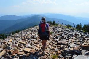
Quick Facts: Location: Selkirk Mountains Land Agency: Colville National Forest Round Trip: 14.0 miles Elevation Gain: 4,000 feet Contact: Sullivan Lake Ranger District, Colville National Forest Recommended Guidebook: Day Hiking Eastern Washington by Craig Romano and Rich Landers (Mountaineers Books) Notes: trail passes through a recent fire zone—be aware of hazards such as falling snags.…
Location: Colville National Forest, Ferry County, Wa Land Agency: National Forest Service Roundtrip: 9.0 miles Elevation gain: 1,700 feet Contact: Colville National Forest, Republic Ranger District Notes: beware of rattlesnakes Access: From Republic follow SR 21 south 12.3 miles to trailhead located just within the Colville Indian Reservation Boundary. If coming from Wilbur, follow SR…