Region
Central Cascades

Quick Facts: Location: Skykomish River Valley, US 2 Land Agency: Washington State Parks Roundtrip: 11.5 miles Elevation gain: 1,575 feet Green Trails Map: Contact: Wallace Falls State Park Notes: Discover Pass required; Dogs must be leashed; Camping requires a permit-attain from park prior to trip. Access: From Everett, follow US 2 for 28 miles east…
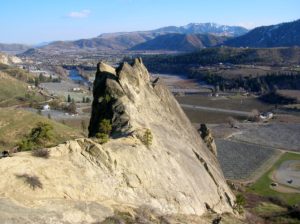
Quick Facts: Location: Wenatchee River Valley near Leavenworth Land Agency: Washington State Parks Roundtrip: 1.5 miles Elevation gain: 400 feet Green Trails Maps: Wenatchee Mission Ridge no. 211S Contact: Peshastin Pinnacles State Park Notes: Discover Pass required; dogs must be leashed. Access: From Leavenworth follow US 2 east for 9 miles turning left onto North…

Quick Facts: Location: Maltby Land Agency: Snohomish County Parks Roundtrip: 3.2 miles Elevation Gain: minor ups and downs Access: From SR 522 in Maltby (5.0 miles east of Woodinville; 8.0 miles west of Monroe) head east on Paradise Lake Road for 1.7 miles to trailhead. Notes: Dogs must be on leash. Park open 7 am…

Quick Facts: Location: Lynnwood Land Agency: Snohomish County Parks Roundtrip: 2.5 miles Elevation Gain: 425 feet Contact: Snohomish County Parks Special Notes: Dogs must be leashed; park open 7 am to dusk: do not park on road Access: From Everett, head 10 miles south on I-5 to exit 183. Follow 164th Street SW west for…

Quick Facts: Location: Sultan Basin Land Agency: Washington Department of Natural Resources Roundtrip: 13.8 miles Elevation Gain: 2,140 feet Green Trails Map: Index WA- No. 142 Notes: Dogs must be on leash; All hikers are required to stop and register (no fee) at kiosk at Olney Pass upon entering Sultan Basin Watershed. Access: From Everett…

Quick Facts: Location: Blewett Pass Land Agency: National Forest Service Roundtrip: 2.8 miles Elevation Gain: 400 feet Green Trails Map: Wenatchee/ Mission Ridge, WA- No 211S Contact: Cle Elum Ranger District: Okanogan-Wenatchee National Forest Access: From Cle Elum follow WA 970 east for 7.0 miles to US 97. Continue north on US 97 for 14.0…

Quick Facts: Location: Skykomish River Valley Land Agency: Mount Baker-Snoqualmie National Forest Roundtrip: 10.5 miles Elevation Gain: 1,350 feet Notes: Northwest Forest Pass required; Dogs permitted on leash. Contact: Skykomish Ranger District: Mount Baker-Snoqualmie National Forest Green Trails Map: Alpine Lakes-Stevens Pass-No. 176S Access: From Everett drive US 2 east to Skykomish. Then continue for another…

Quick Facts: Location: Sultan Basin Land Agency: Washington Department of Natural Resources Roundtrip: 9.6 miles Elevation gain: 1,600 feet Green Trails Map: Mountain Loop Highway 111SX Contact: Snohomish County Public Utility District Notes: Register (no fee) at entrance to watershed. Dogs must be on leash. Access: From Everett follow US 2 east to Sultan. At…
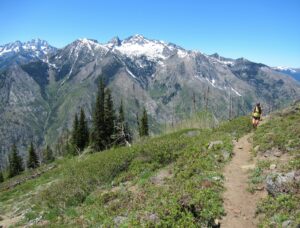
Quick Facts: Location: Central Cascades Land Agency: Okanogan-Wenatchee National Forest Roundtrip: 11.2 miles Elevation Gain: 4,700 feet Notes: rattlesnakes are common along lower portions of trail. Green Trails Map: Alpine Lakes East Stuart Range 208SX Contact: Wenatchee River Ranger District (Leavenworth) More information: Day Hiking Central Cascades 2nd edition (The Mountaineers Books) Access: From Leavenworth follow the…

Quick Facts: Location: Wild Sky Wilderness, Skykomish River Valley Land Agency: National Forest Service Roundtrip: 8.6 miles Elevation Gain: 1,750 feet Green Trails Map: Alpine Lakes West 176S Contact: Skykomish Ranger District: Mount Baker-Snoqualmie National Forest Notes: Northwest Forest Pass or Interagency Pass required. Access: From Everett, head east 41 miles on US 2 to Baring.…