Mount Wells– Victoria area summit gushes with flowers and views

Quick Facts:
Location: Victoria—Langford, BC
Land Agency: Capital Regional District Parks
Roundtrip: 2.0 miles/ 3.2 km
Elevation gain: 865 feet/ 264 m
Maps: CRDP site
Contact: Capital Regional District Parks
Notes: dogs permitted on leash; please stay on trail to protect rare plants
Access: From Victoria, follow Trans-Canada Highway 10.5 for miles (17 km) exiting onto the West Shore Parkway. In .2 mile (.3 km) turn right at a roundabout onto Amy Road. After .5 mile (. 8km) turn left onto Sooke Lake Road. In .2 mile (.3 km) turn left onto Humpback Road and continue for .9 mile (1.4 km) to trailhead.
Good to Know: Exceptional Wildflowers, Historic Interest, Exceptional Views, dog-friendly, kid-friendly

One of the best wildflower hikes in the Capital Regional District, Mount Wells not only gushes with gorgeous blossoms, but with exceptional views, too!Starting from the base of the Humpback Reservoir which once supplied Victoria with its drinking water from 1915 until the 1990s, start hiking. Paralleling Humpback Road and via stairs climbing across the old water pipeline. Then carefully cross the road and the pipeline once again—and begin ascending steep slopes of open Douglas fir – arbutus (madrona) forest.
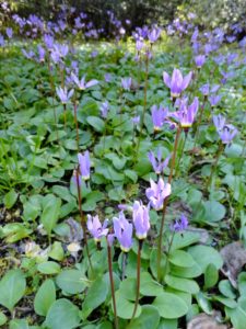
At .6 mile (1 km), the way heads up very steep and rocky ledges that’ll have you using your hands. The old, worn, and striated rock may have you thinking you’re hiking in the Maritimes. Emerge onto polished open ledges lined with lodgepole pine, manzanita, Garry oaks and flowers! The blossoms are brilliant, especially in late Spring. Camas, shooting star and elegant satinflower transform Wells into a purple mountain majesty. Look for prairie lupine—found nowhere else in Canada. And watch the skies for vultures and raptors.

Railings help provide the way and protect you from cliff edges while also protecting the delicate flowers from trampling. At .8 mile/ 1.3 km crest an open with excellent views over the greater Victoria area and out to the Gulf and San Juan islands. Embrace them and then continue, dropping into a small saddle, before making the final climb to Well’s 1,155-ft (352-meter) summit.
Savor more sensational views—to the Humpback Reservoir, Mount Finlayson and Finlayson Arm north and Mount McDonald west in the closed-to-hiking Sooke Hills Wilderness Regional Park Reserve encompassing Victoria’s water supply. And delight in the brilliant blossoms carpeting the summit.
For more information on this hike and 135 other spectacular Salish Sea hikes (including many near Victoria), consult my Day Hiking The San Juan and Gulf Islands Book.
For more information on where to play and stay in the Victoria Area, check out Northwest TripFinder

