Lake Ingalls
Capture breathtaking reflective views of Mount Stuart
Quick Facts:
Location: Alpine Lake Wilderness, Teanaway Country
Round Trip: 9.2 miles
Elevation Gain: 2600 feet
Contact: Okanogan-Wenatchee National Forest, Cle Elum Ranger District, https://www.fs.usda.gov/okawen/
Detailed Information: 100 Classic Hikes Washington (Mountaineers Books)
Notes: Northwest Forest Pass required; dogs prohibited; wilderness rules apply; no camping at lake.
Green Trails Map: Alpine Lakes East Stuart Range No. 208S
Access: From Seattle or Ellensburg take I-90 to exit 85 and follow SR 970 east 6.5 miles. Turn left onto Teanaway Road and drive north 13 miles to junction at 29 Pines Campground. Then bear right onto rough FR 9737 and follow for 9.7 bumpy miles to trailhead.
Good to Know: Dog prohibited, Larches, Alpine Lakes Wilderness, Backpacking, Crowded on weekends-consider a weekday visit, practice Leave No Trace Principles
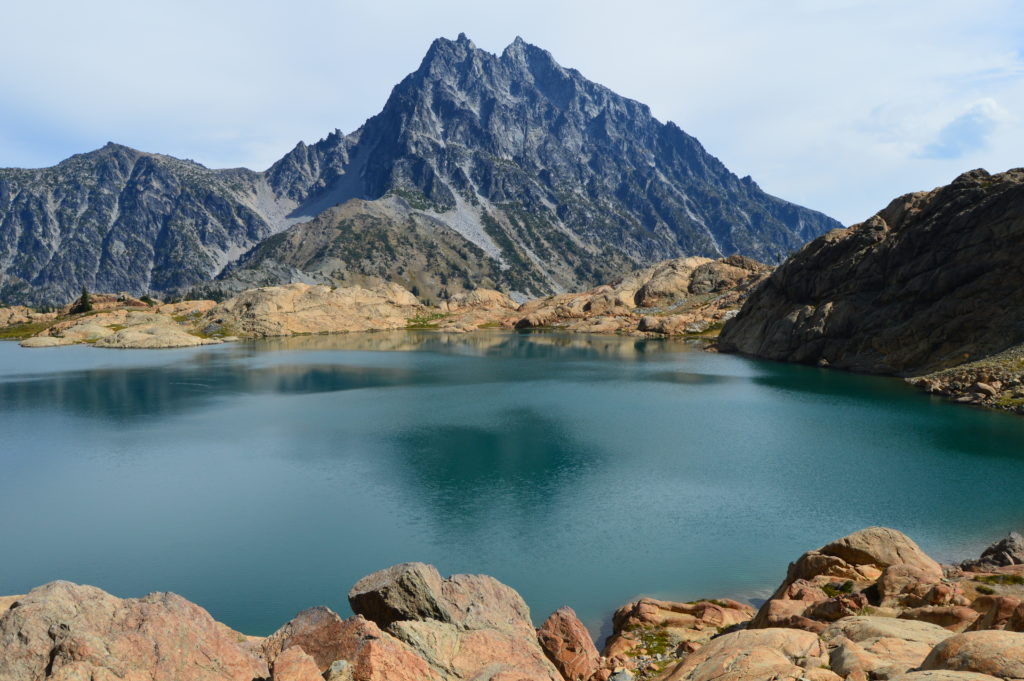
Cradled in a high barren basin beneath the rocky façade of Ingalls Peak; Lake Ingalls is a sight to behold. When its icy waters lay calm capturing reflections of the sheer rock face of 9415-foot Mount Stuart, one of the highest non-volcanic peaks in the state—the view is striking. When surrounding alpine larches set the basin aglow in gold—the scene is simply spellbinding.
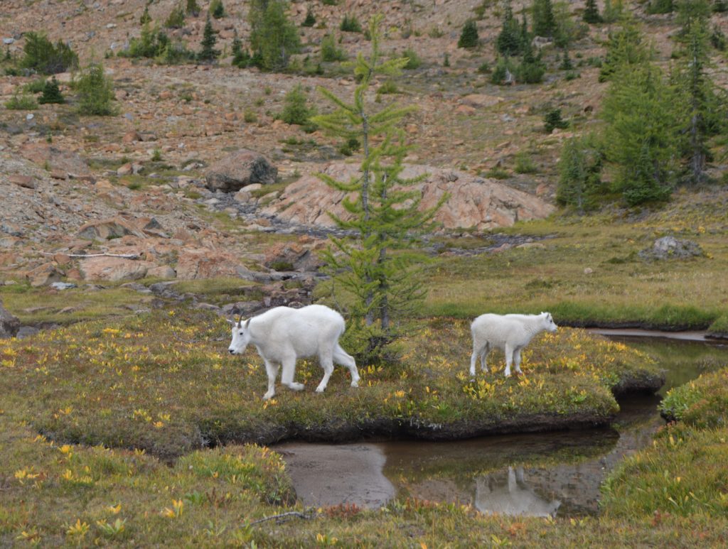
One of the most popular hikes in the Teanaway Country, Lake Ingalls is a gorgeous place indeed. But it also occupies a fragile alpine environment. Dogs and groups over 12 are prohibited. Camp only at designated sites and keep your off trail wanderings off of the meadows. Be mindful of the area’s mountain goats too—they’re prolific here. Observe then from a respectable distance.
Start by heading north on the Esmeralda Trail and soon bear right onto to the Lake Ingalls Trail. Now steadily ascend switchbacking through open forest. Cross an old jeep track several times—a remnant scar of the area’s mining history. Bear left at a junction with a trail leading to Longs Pass. It’s a worthy side trip for strong hikers. The lake Ingalls Trail continues left traversing talus, meadows, and steep slopes gullied by cascading creeks. Views over the Esmeralda country to Mount Rainier expand with each step. At just over 3.0 miles reach a junction and the wilderness boundary at Ingalls Pass.
The trail right leads to excellent designated camping spots before dropping into the Headlight Creek basin and returning to the Lake Ingalls Trail. It makes for a good alternative return from the lake. The main trail heads left along a rocky ridge through clusters of whitebark pines and groves of alpine larches. Views across the Ingalls Creek Valley to Mount Stuart are superb.
The way then heads up and down crossing talus, boulder fields, meadow patches and gurgling creeks. It’s slow going requiring the occasional use of a hand or two. Pass the trail coming from Ingalls Pass and hop over Searchlight Creek—then follow a path of sorts carefully scrambling up steep ledge and rock emerging to the open basin cradling Lake Ingalls. The basin was scoured by a long gone glacier leaving behind ledges of polished rock and pure rugged beauty. The view of Mount Stuart across Ingalls’s rippling or placid waters is a classic. Now, like the prospectors of yesterday—scout the basin and stake yourself a claim—a great spot to plop down and reap the scenic riches of this setting.
For more details on this hike and many other amazing hikes throughout the state, pick up a copy of my best selling 100 Classic Hikes Washington (Mountaineers Books).