Capitol Peak
The views rule from this prominent peak near Olympia
Quick Facts:

Location: Capitol State Forest Land Agency: Washington Department of Natural Resources (DNR) Distance: 17.0 mile loop Elevation Gain: 2300 feet Contact: Washington Department of Natural Resources (DNR); South Puget Sound Region Office Notes: dogs permitted on leash; Trails also open to mountain bikes and horses; Discover Pass required Recommended Guidebook: Urban Trails Olympia (Mountaineers Book)
Access:From Olympia, head south on Black Lake Boulevard (which becomes 62nd Ave). Then turn left on Delphi Road and proceed bearing right onto Waddell Creek Road. Continue, entering the Capitol State Forest and bearing right onto Sherman Valley Road. Then follow this road which becomes the C Line. Stay on the C Line for 2.5 miles turning left onto C-6000. Then proceed 1.8 miles to its end (just past campground) at the Fall Creek Trailhead.
Good to Know: dog-friendly, snow-free winter hike, Practice Leave No Trace Principles, mountain biking, excellent trail running
Capitol Peak is the second highest (just misses highest by one foot) summit in the Black Hills. Its summit is marred with towers—but its views are grand from Rainier to the Pacific and a whole lot more. This Cap Forest Classic long day hike or challenging trail run involves a big loop from Fall Creek to Cap Peak. The distance is long but the grade is generally gentle. And the payoff? Views, attractive forest, cascading creeks—and more views!
This loop is bisected by roads at numerous points making much shorter options possible if 17 miles is too daunting. Otherwise, accept the challenge and show those mountain bikers that anyone can do this loop on two wheels—two feet however—that’s an accomplishment!
From the trailhead, head north on the Greenline coming to a junction. The Greenline—your return route—continues straight. You want to go left on the Wedekind Trail. Now begin a long gentle ascent passing through a patchwork of mature standing timber, younger regenerating stands, and past harvest areas.
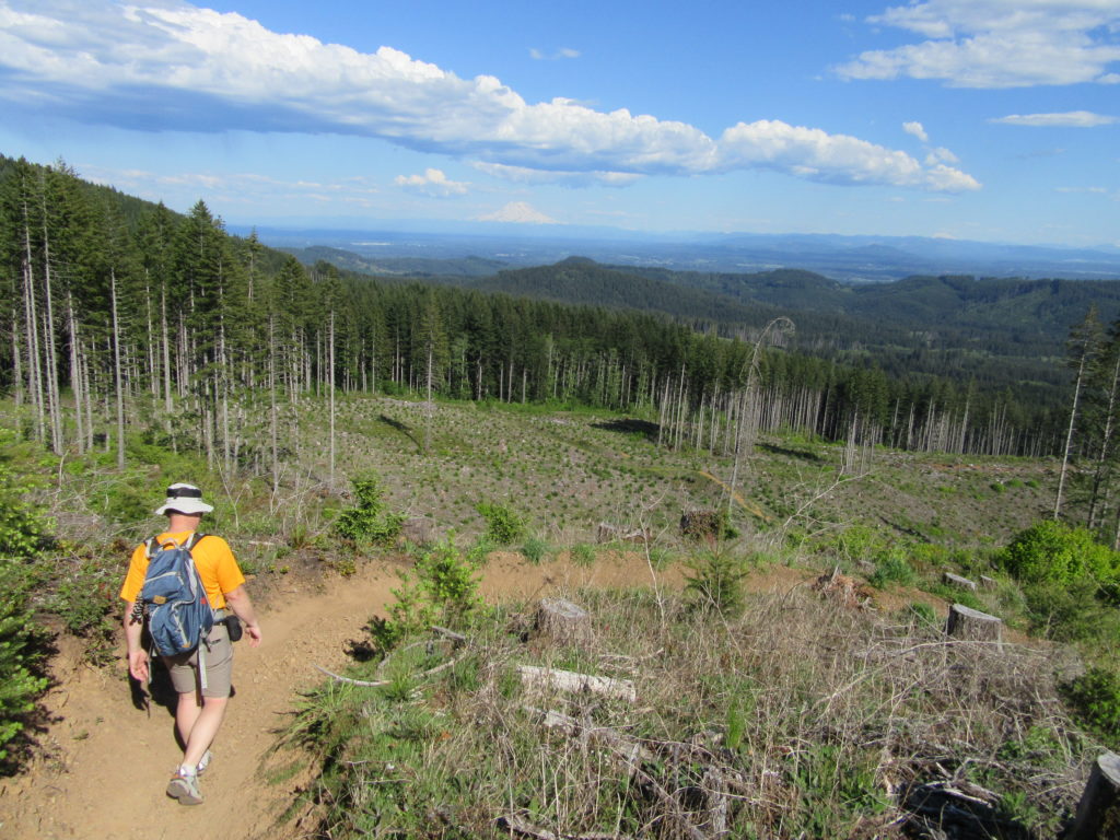
Continue meandering on well-built and maintained tread making many bridged creek crossings including one exceptionally attractive one in a pretty ravine. Traverse a cut providing sweeping views south of Mounts Adams and St. Helens and the Goat Rocks. After crossing a new skid road, come to a junction with the Greenline Tie Trail. Here it is possible to hike/run right for a 9.3 mile loop.
The Grand Cap Peak loop continues left. Come to a big bridge spanning a small creek. Then after passing through a new cut, the way follows one of the many old logging railroad beds crisscrossing the forest. At 6.5 miles reach a trail junction and the C-Line and D-1000 roads at the defunct Wedekind Picnic Area. Cross the C-Line and follow the Crestline Trail north.
Now enjoy easy ridgeline cruising through silver firs and a lush green carpet. The way dips once on its generally gentle ascent. Cross the C-Line and alternate between fir forests lined with oxalis (pretty white blooms in late spring) and raspberry cloaked “balds” reminiscent of the southern Appalachians; the trail is a pure delight to travel. Teaser views of the Cascades, Olympics, and Willapa Hills are had along the way.
Cross the C-Line again. Then climb some more on a gently rolling ridgeline. Cross another road. The trail now paralleling two roads climbs a small knoll—then descends to where the roads intersect. Cross the road left and follow trail through huckleberries paralleling the C-4000.
At 10.5 miles reach a junction with the Greenline Trail. But before returning on that trail, walk the road straight a short distance to a three-way junction. Take the gated middle road and climb steeply 0.6 mile to the 2659-foot summit of Capitol Peak, second highest summit in the Black Hills. Highest summit, 2600-foot Larch Mountain can be seen to the north. It’s trail-less and treed—but not with larches—and lacks views.
Here on Cap Peak beneath a skyline of communications towers, reach out to sweeping views. East to the Cascades, from Mounts Baker to Adams. Rainier directly in front of you rising above the Bald Hills. Extending to the north are the finger peninsulas and inlets of the South Sound. To the west, the Satsop Towers rise above the Chehalis Valley, while the Olympics and Pacific Ocean can be seen in the distance
Then retrace your steps back to the Greenline junction for a shorter albeit steeper return to your start. Following tight switchbacks, the way loses elevation rapidly. It then makes a long traverse crossing new logging roads and coming to a clearcut with expansive views east. Another round of tight switchbacks await you next before coming to a junction with the Greenline Tie.
Continue left and follow another old logging rail line and cross another cascading creek before crossing the C-Line. Continue descending soon coming to a skid road. The trail follows this road left for a short distance—then enters a clearcut. The trail comes to another road—head right on it soon returning to trail. The way then crosses a creek and passes two spurs leading to the Fall Creek Campground before returning to a familiar junction with the Wedekind Trail. Now turn left and return to your start at 17.0 miles. Hike well done!
Capitol Peak is one of the featured destinations in my Urban Trails Olympia (Mountaineers Book). For more a detailed description of this hike (including a map and elevation and mileage stats); and other trails in the Capitol State Forest (including many not found in other guides), pick up a copy of this book today!
