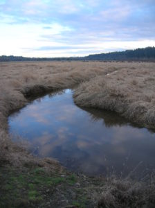
La Center Bottoms─Wintering bird haven on the East Fork of the Lewis River

The La Center Bottoms is a vibrant wildlife viewing area
Quick Facts:
Location: La Center, Clark County Wash.
Land Agency: Clark County Parks
Roundtrip: 2.0 miles
Elevation Gain: 30 feet
Special Note: Dogs permitted on leash.
Access: From Vancouver, head north on I-5 to Exit 16. Turn right onto La Center Road and proceed for 1.6 miles to the bridge over the East Fork Lewis River. Immediately upon crossing bridge and entering town of La Center turn right on Aspen Ave, then immediately turn right again for trailhead parking near water reclamation plant.
Contact: Clark County Parks
Recommended guidebook: Urban Trails Vancouver WA (Mountaineers Books)
Good to know: partial wheel chair accessible, kid-friendly, dog-friendly, exceptional bird watching, snow free winter hike, practice Leave No Trace Principles
The La Center Bottoms is the crown jewel of the 2,000-acre-plus 10-mile long East Fork Lewis River Greenway. Here hikers of all ages and abilities (much of the site is wheelchair accessible) have the opportunity to explore a sprawling wetland saturated with wildlife—especially birds. A National Watchable Wildlife site, La Center Bottoms is a great place for observing birds year round. And during the winter months this is a great place for observing swans.
Start on a paved path swinging to the south of the city’s water treatment plant. Operated by Clark Public Utilities, the utility company along with the city of La Center, TDS Telecom, and private individuals were instrumental in the preservation of the 300-plus acre La Center Bottoms Stewardship Site. The county through its Legacy Lands Program along with the Columbia Land Trust have made preserving lands along the East Fork Lewis River and its restoration a priority.
Next, the path skirts Sternwheeler Park, a gorgeous manicured city park with sculptures, picnic tables, historic displays and an outdoor amphitheater. Connecting the city to the bottoms, feel free to roam Sternwheeler’s grounds, especially its stairways leading to nice views overlooking the bottoms.
For La Center Bottoms continue on the main path crossing Brezee Creek on a little bridge. The trail then transitions to a wide gravel path and reaches a T-junction shortly afterwards. The path left climbs up a wooded bluff to terminate at a school. You want to head right passing some majestic Garry oaks before coming to a bird blind and great view of the sprawling wetland bottoms. In winter the area becomes a shallow lake harboring hundreds of geese and ducks and a few tundra swans thrown in for good measure! Eagles frequently survey the grounds from surrounding trees.
The main path continues past the blind and crosses a channel on a sturdy bridge. The path then proceeds south with the bottoms to the east and the East Fork of the Lewis River to the west. At .6 mile you’ll reach the end of gravel accessible trail. The trail however continues for another 0.4 mile on a grassy path ending at a fence line on the preserve’s southern boundary. Look for scrub jays in the scrappy vegetation lining the trail and look for Mount Hood hovering over the flats.
For more information on La Center Bottoms and other great hiking destinations throughout Clark County, pick up a copy of my brand new Urban Trails Vancouver WA guidebook.
Get your copy today and start discovering great local trails!
For Information on other family-friendly things to do in and around Clark County, Consult Northwest TripFinder
