Mount Spokane–Savor spectacular views from this prominent peak above Washington’s second city
Location: Mount Spokane State Park
Land Agency: Washington State Parks
Roundtrip: 6.0 miles
High Point: 5,883 feet
Elevation gain: 1,000 feet
Difficulty: moderate
Map: Mount Spokane State Park (Dharma Maps)
Contact: Washington State Parks
Note: Discover Pass Required; dogs permitted on leash
Access: From Spokane, follow US 2 north 10 miles to Mead. Turn right onto SR 206 and travel east approximately 20 miles to the Bald Knob Picnic Area and campground in Mount Spokane State Park. Trail begins off of park road across from entrance to the picnic area.
Good to know: Dog-friendly, exceptional views, historic, kid-friendly, Practice Leave No Trace Principles; Don’t be a surface pooper; leave the music home
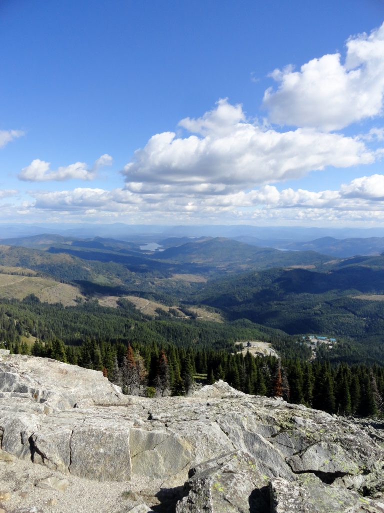
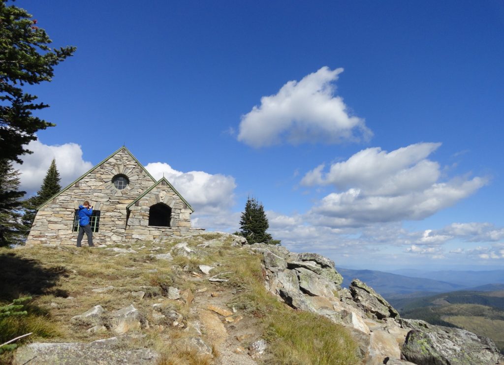
Rising above the Spokane Valley and neighboring Rathdrum Prairie, 5,883-foot Mount Spokane is a prominent local landmark. A southern outpost of the Selkirk Mountains, it’s a local favorite spot for outdoor recreation—particularly for hiking, trail running, mountain biking, horseback riding and skiing. There are over 100 miles of trails and fire roads within this nearly 14,000-acre park, the largest state park within Washington. If you have never visited this spectacular park, then a trip up Mount Spokane’s broad summit with its eloquent historic Summit House is a great introduction.
Yes, you can drive to the mountain’s 5,883-foot summit. But a nice way to attain it is via a three mile hike starting from the park’s Bald Knob picnic and camping area. Starting from an elevation of 5,100-feet, you won’t be enduring too much of a vertical challenge on the way to the summit.
Locate Trail No. 130 across from the campground and begin traversing open forest on high slopes granting excellent views west across rolling hills and prairies. Enjoy one mile of pure delight skirting beneath Mount Spokane’s summit. Come to a junction with the dirt Upper Kit Carson Loop Road (gated) at an attractive Civilian Conservation Corp (CCC) constructed lodge used primarily by skiers for warming up.
Now take Trail No. 140 and follow it right upward to Mount Spokane’s summit. The trail was just recently widened and rebuilt adding new switchbacks making it a little easier of a climb. The way is popular with mountain bikes, so be aware of their presence and perhaps plan your hike for mid-week when it’s a lot less traveled.
Winding your way through stands of old growth, old fire patches and some meadows reach the Mount Spokane Summit Road just below the summit. Then turn left and walk .1 mile up a wide trail to the CCC-built stone Vista House at the mountain’s 5,883-foot summit. Enjoy the views—they’re breathtaking and expansive. Look east into Idaho to the Cabinet Mountains and massive lakes Pend Oreille and Coeur D’Alene. Look north along the rounded lofty spine of Washington’s Selkirk Mountains. Look south across the Spokane Valley to Mica Mountain and the Dishman Hills. And wander out onto the summit talus slopes for views west across prairies to the empty channeled scablands and Columbia Plateau. If the wind is whipping, step inside the Vista House for a warm-up. Then pull your map out and start planning future hiking trips in this sprawling and trail-saturated state park.
Mount Spokane is one of my 100 Classic Hikes of Washington. Pick up the best selling book and start discovering the best hikes in the Evergreen State!
For information on where to stay and other attractions in the Spokane Area check out Northwest Trip Finder.
Great photos!!! I’m having some difficulty “placing” the last one, though. Maybe you could help me out with that? I’ve hiked everywhere from the Pacific Coast to the Continental Divide & beyond and have seen quite a few places like that in your photo. Naming the mountain in the background would do it for me – if you wouldn’t mind…
Thanks!
Pete Schell
Elk, WA