Silver Falls Loop– Thundering Waterfall at Rainier’s Ohanapecosh
Quick Facts:
Location: Ohanapecosh
Land Agency: Mount Rainier National Park
Roundtrip: 2.7 miles
Elevation Gain: 350 feet
Contact: Mount Rainier National Park
Detailed Information: Day Hiking Mount Rainier (Mountaineers Books)
Green Trails Map: Mount Rainier National Park 269S
Notes: National Park Entrance Fee or Interagency Pass required; dog prohibited
Access: From Packwood, follow US 12 east for 7.5 miles. Turn left onto SR 123 and continue 3.6 miles. Turn left and proceed to Ohanapecosh Visitor Center. From Enumclaw, follow SR 410 east for 41 miles to Cayuse Pass. Turn right and continue south on SR 123 for 13 miles turning right for the Ohanapecosh Visitor Center.
Good to Know: exceptional waterfall, historic, interpretive trail, old-growth,, kid-friendly, practice Leave No Trace Principles
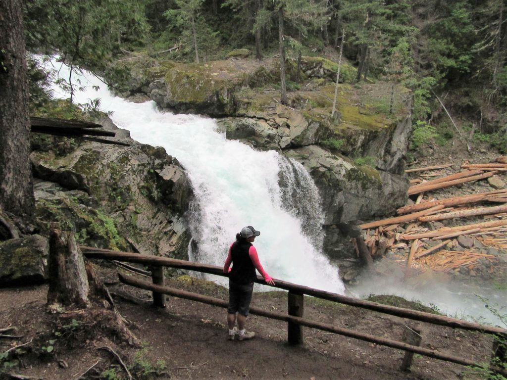
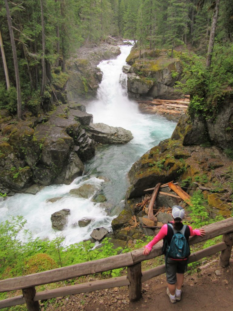
Careening over a series of ledges before plunging 40 feet into a deep blue pool, Silver Falls is a dramatic sight. And it’s easily accessible. A very short trail leads to it from SR 123. But the best way to experience this cascading spectacle on the Ohanapecosh River is by hiking to it on a delightful loop from the Ohanapecosh Visitors Center. En route you’ll pass the site of an old hot springs resort and some big old trees.
Park at the Ohanapecosh Visitors Center and walk a short distance up the adjacent campground’s “B” loop road for the trail. Take it—walking at first on what was once an old road. Soon come to the Ohanapecosh Hot Springs perched on a forested bench above the Ohanapecosh River. While the springs are now warm and soaking is verboten (be sure to stay on the trail and boardwalk), the area has an interesting human history.
Take time to read the few interpretive signs—but the story of the old springs resort here is much deeper. At one time the Ohanapecosh Hot Springs consisted of more than a dozen springs (some as hot as 120 F). In 1913, while this area was within national forest lands, Eva O’Neal established a commercial tent camp at the springs. Owing to the springs’ growing popularity, local entrepreneur N.D. Tower developed a resort at them in 1921. By this time thousands of folks were flocking to the springs for their supposed therapeutic powers. Tower contracted a crew to construct a road to the springs from Packwood. By 1925, Tower and investor Dr. Albert W. Bridge had constructed a small hotel and two bathhouses in addition to a tent camp and several cabins. They had grandiose plans for the springs to build a great resort. However, in 1931 Mount Rainier National Park was expanded to include the hot springs (long a park service objective). The resort was allowed to continue on its current small scale. The resort eventually added more cabins in the 1940s, but the facilities were considered substandard and an embarrassment to the park. By 1960, the resort was closed down and by 1967 all of the buildings were removed. Today, nothing remains of the old resort, bathhouse and soaking pools. The park service has allowed the springs to revert back to their natural state. You can check out old pictures of the resort in the visitor center. All that remains of the springs now are boggy seeps which languidly flow into the nearby river.
Walk on a boardwalk past several seeps and come to a junction. The trail right is a continuation of the short Hot Springs interpretive trail. It leads past more pools returning to the visitor center in about 0.4 mile. The Silver Falls loop continues straight soon crossing a pretty little cascading creek. Shortly afterward cross the much larger Laughingwater Creek crashing down from the Cascade Crest. Just beyond the crossing reach a junction where the Laughingwater Trail takes off right. This is also the shortcut route to the falls if you’re not intent on doing much hiking to see them.
The loop bends left soon coming to a striking vista of Silver Falls. Stare out at the roaring river careening over tiered ledges before plunging 40 feet into a deep pool. Towering firs and hemlocks line the waterway. The river continues through a deep and narrow chasm resembling a flume. Watch for tenacious dippers searching for tasty insect larvae in the rapids. They can often be seen perched on ledges and rocks in the spray zone.
Continue hiking and being sure to stay behind the railings in place. The ledges beyond are wet and slippery and more than a couple of folks ignoring prudence have slipped and met a grim fate in the fast moving waters below. Keep children nearby and stay on the trail. Now cross the river on a high bridge where the river churns below in a tight rocky chasm. At about 1.3 miles come to a short spur leading to a spectacular viewpoint right at the falls. If you’ve ever wondered what Ohanapecosh means, a commonly accepted version of its origin credits it to an Upper Cowlitz Indian name meaning, “clear stream or deep blue.” Stare into that plunge pool before you and see a deep blue strand emerge from a clear stream.
Now continue hiking soon coming to a junction with the Eastside Trail. Continue on the loop by hiking left. The trail climbs a small rise traversing slopes shrouded in ancient timber. It briefly brushes against a wall of mossy ledges with overhanging shelves—then skirts a small seasonal wetland pool before slowly descending. At. 2.7 miles the trail returns to the Ohanapecosh Campground terminating next to the Amphitheatre at the west end of the campground bridge spanning the Ohanapecosh River.

For detailed information on other Mount Rainier National Park hikes, as well as many other hikes throughout the state, pick up a copy of my 100 Classic Hikes Washington (Mountaineers Books).
For information on where to stay and on other things to do on the Olympic Peninsula, check out Northwest TripFinder