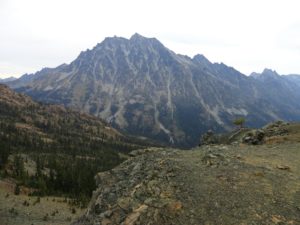
Longs Pass- Short and steep hike to in-your face views of Stuart

Quick Facts:
Location: Alpine Lakes Wilderness
Land Agency: National Forest Service
Round Trip: 5.8 miles
Elevation Gain: 2100 feet
Contact: Cle Elum Ranger District, Wenatchee-Okanogan National Forest
Green Trails Maps: Aline Lakes East –Stuart Range no. 208SX
Notes: Northwest Forest Pass or Interagency Pass required; Dogs-prohibited
Access: From Seattle take I-90 to exit 85 and follow SR 970 east 6.5 miles. Turn left onto Teanaway Road and drive north 13 paved miles. Bear right onto gravel FR 9737 and follow for 9.7 miles to trailhead.
Good to Know: summer wildflowers, alpine views, wildlife watching; practice Leave No Trace Principles
Mention classic hikes in Washington and Lake Ingalls instantly comes up. One of the most popular hikes in the Teanaway Country, Lake Ingalls is a gorgeous place indeed. But it also can be one of the most crowded trails in the region. Consider escaping the crowds and opting for nearby Longs Pass. It’s a lot shorter—but steeper, and will give you a great workout. And this 6250-foot pass gives you one of the best views of Mount Stuart.
The pass lies directly south of 9415-foot Mount Stuart, one of the highest non-volcanic peaks in the state. From the barren pass, stare across the Ingalls Creek Valley at the massive mountain. Start you hike by heading north on the Esmeralda Trail, an old mining road-turned trail. At .3 mile, come to the Lake Ingalls Trail. Take it heading right and steadily ascending switchbacking through open forest. Cross an old jeep track several times—a remnant scar of the area’s mining history. Soon reach meadows and views west into the Esmeralda Basin.
At 1.7 miles comes to a junction. This is your exit from the crowds. Head right and steeply climb. You’ll cross the old jeep track—made in the 1930s to access mines and claims. The climb is relentless, but there are views all along the way. Stare west across the Esmeralda Basin and try to image the fury of mining activity that once went on there. Scars on the land and whispers in the wind are mostly all that remain of the area’s mining boom.
The slopes leading up to Longs Pass are pretty barren. But a few pines and larches tenaciously cling to survival in this harsh environment. Come late September the alpine larches glow a brilliant yellow and help add some color to the bleak ridges. At 2.9 miles reach the pass-and—BAM—in your face views of Stuart. A trail continues steeply down the northern slopes from the pass. It’s used primarily by climbers to access the big mountain before you. Kick back and enjoy the view—and perhaps a mountain goat or two will saunter by as you revel in this alpine beauty.
For detailed information on Lake Ingalls and many other great hikes in and around Snoqualmie Pass, pick up a copy of my best selling 100 Classic Hikes Washington (Mountaineers Books). Get your copy today and start exploring some of the best trails in the state!
