Boulder River- waterfalls among old-growth forest
canyon walls surrounding Boulder River.
Quick Facts:
Location: Boulder River Wilderness, near Darrington
Land Agency: National Forest Service
Round trip: 8.6 miles
Elevation Gain: 750 feet
Green Trails Maps: Mountain Loop Highway 111SX
Access: From Arlington follow SR 530 for 20 miles. Just beyond Milepost 41 near a subdivision turn right onto FR 2010 and continue for 3.7 miles to trailhead.
Contact: Darrington Ranger District: Mount Baker Snoqualmie National Forest
Notes: Wilderness rules apply
Good to know: dog-friendly, kid-friendly, snow free winter hike, exceptional waterfalls, exceptional old-growth, practice Leave No Trace Principles

An excellent hike anytime of the year, Boulder River is a superb fall and winter destination. It’s one of the few wilderness hikes that you can do on the west side of the Cascades that usually stays snow-free all winter long. Boulder River’s rapids and cascades and the waterfalls that crash down off of steep slopes feeding it are absolutely stunning during and after winter rains. And if it is raining, the thick ancient forest canopy over the trail will keep you well sheltered.
It’s a tossup as to what will leave you in more awe on this trail—the waterfalls or the old-growth forest. The moss-draped giant trees of the Boulder River Valley make up one of the last remaining low-country old-growth forests in Snohomish County. And growing among the Douglas-fir, western hemlock and western red cedar is a handful of Sitka spruce, a real rarity this far inland from the coast. These primeval trees are all protected within the 49,000-acre Boulder River Wilderness assuring that they’ll be around to marvel future generations of hikers.

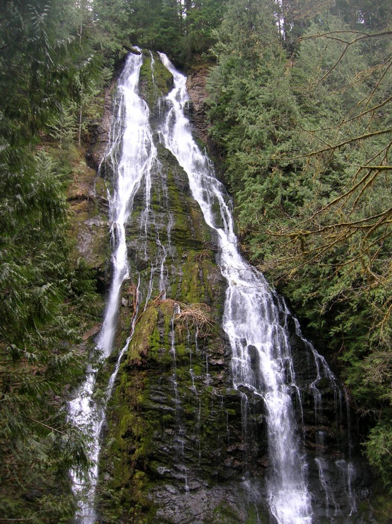
From the trailhead, the Boulder River Trail travels 4.8 miles up a deep canyon. Numerous waterfalls tumble down the narrow canyon walls into the rushing river. The first one you will encounter lies about 1 mile down the trail. Here just beyond the wilderness boundary, stand in awe soaking up a spectacular unnamed twin waterfall crashing down into the river. There is more to come but this spot makes for a good turning around spot for young children.
For those of you intent on carrying on, continue up the trail traveling deeper into the moisture-laden emerald valley. With more than 150 inches of rain falling here each year, the Boulder River is as lush as any Olympic Mountains river valley. After 4.8 miles of pleasant hiking the trail ends at a campsite along the river. The way once crossed the river here and continued all the way to Tupso Pass and Three Fingers. Long abandoned, the forest has reclaimed it. Now retrace your steps back to the trailhead once again admiring the ancient giants and cascading waters that entranced you on the way in.
For more detailed information on this hike and many more in the Darrington area, pick up a copy of my best selling Day Hiking North Cascades 2ed.